 Live Music Archive
 Librivox Free Audio
 Metropolitan Museum
 Cleveland Museum of Art
 Internet Arcade
 Console Living Room
 Books to Borrow
 Open Library
 TV News
 Understanding 9/11
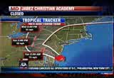
tv Fox 5 News at 5 FOX October 29, 2012 5:00pm-6:00pm EDT
5:00 pm

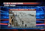
leadership in washington that will actually bring people together and get the job done and could not care less if it's a republican or a democrat. i've done it before, i'll do it again. i'm mitt romney, and i approve this message. sandy causing damage in ocean city, maryland. at this hour, the hurricane is picking up speed and should make landfall soon. thanks for staying with us for our continuing coverage as hurricane heads up the coast. i'm shawn indian say. >> and brian boller it. school closings already coming in as you might expect. find those scroll at the top of your screen. there's helpful information about shelters, numbers for power companies and more scrolling at the bottom of the
5:01 pm

screen. >> sandy should make landfall in southern new jersey; but the impact will be felt for miles and the worst is yet to come. at last check, the storm center was within 50 miles of the city. city. it is forming a powerful super storm like we've never seen before. >> for the latest let's turn to sue in the weather center. sue, i understand this storm about to make landfall near atlanta city. >> yeah. going to be real close. we just got the update from the national hurricane center. it's 0 miles to the south of atlanta city, 30 miles from cape may. so you can do the math. still moving to the north, northwest at 20 miles per hour. it will be ashore probably between 6 and 6:30 somewhere in south jersey. maybe the delaware bay gets clipped. >> an amazing forecast. the big change is that it sped up a little bit more than we thought.
5:02 pm

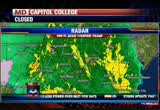
>> right. >> it's probably making landfall three hours faster faster. we were thinking right there at it will wear bay. >> and it's still got that incredible record-setting low pressure of 940milibars, the difference now between what has been a tropical system turning into winter-like system. the wind field will expand out. >> up in rhode island there was an amateur weather station that was 84 les per hour wind gusts >> wow. >> so the package of high winds extends out far. >> want to talk about radar here locally, because some bands of heavy rain getting ready to moven through. we're going to spotlight them for you here. >> this yellow band pushed through baltimore. it's still pushing through baltimore, and we know that not only is this where the heavy bands of rain are, but this is where the heavy winds are. as you begin to feel more intensity with the rain outside
5:03 pm
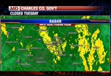
your house or whatever, you're also going to notice that the winds will kick up as well. and i suspect we are beginning now to transition into where anytime now, these wind gusts could be 60 plus. as the storm is. along the eastern shore just into delaware, this line of yellow, the moderate showers out there will really contain the highest winds we'veseen so far. so give them a couple more hours to come on through. i think that's when we'll begin to get more reports of 60 plus miles per hour wind gusts -- these are just gusts. a better way to say that would be occasional gusts within the bands moving on through. and all these bands now are rotating around the hurricane, moving from east to west a. heavy band-aid has moved through baltimore.
5:04 pm
so i suspect if you're in the northern sections of prince george's county into the extreme eastern parts of montgomery county within the next 30 minutes or so, you're going to be getting these heavier rains and the higher wind gusts that are now moving through columbia, severe that park and indianapolis. we're getting a lull now west of 95. over time it will start kicking up. >> one of the hall marks of this system is the winds have been to the south and west. so watch out in delaware and through the bay. those are going to be big winds as the center is just literally about 30 miles away from the coast. gary is beginning do a little bit of measurement here. you can see where we're spotlighting what we expect to be intense rain and wind here within the next hour to 90 minutes as that moves on through. so some of the worst it has to offer will be coming on shore, and then from here, if we do
5:05 pm
tracking if we have a moment, as our storm comes to shore and moves to the west northwest at 28, it will take a track that brings it into south central philadelphia. so along the mason dickson line. we could have winds of 75 miles per hour at two in the morning. and then it progresses up through central philadelphia into new york state, something we didn't even mention here, gary, we're getting gusts of 52, just as we expected. the big winds picking up here, and we'll just end on the fact that sandy is beginning have a snowy side, too. we'll tease you with that and tell you more about the snowy side of sandy with our next update. >> if it's named a super storm it has to come with a little bit of everything. >> yes. >> shawn, back to you. >> thanks, guys. power outages are jumping up now. if you take a look at your screen we can give you the latest numbers. pep key reporting 16,000 customers in the dark. virginia approaching 10,000. in northern virginia beg has 1600 out of power in montgomery
5:06 pm
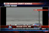
and prince george's counties. >> the heavy surf from hurricane sandy has damaged a fishing pier in ocean city, maryland. >> the mayor said 150 feet of that pier is gone. he said he would sacrifice the other 150 feet of it if it would mitigate the low level flooding going on in his city right now. we're live in the city with the latest now. sherry? >> reporter: well, brian, if only the mayor could make that deal. but i have a feeling hurricane sandy is beginning have none of that, because she is just pounding ocean city from all sides. we're getting the heavy rain, the heavy winds here, the heavy surf. we're getting pelted by sand as well. you can look out here, and that just shows you how ominous this storm is as it gets closer and closer to coming ashore. you can see these massive waves that have been pounding the beach. as the high tide begins to come up, we're starting to see it encroach upon the sea walls again. you can see the trees over
5:07 pm

there just bending in the winds out here. one of the biggest concerns here is that storm surge not only from the ocean; but from the bayside as well. we're seeing flooding on the bayside, some backyards and homes seeing several feet of water. we're seeing streets as well through the area with a foot and a half or more of water. they are impassable. but as you mentioned perhaps the most significant damage, the most memorable damage so far from this storm has been to the fishing pier here in ocean city. about half of it has just been wiped away. it took a beating from all of the heavy surf overnight and all day today. when they came out today to take a look at it, you can see it has just washed away, the pilings buckled under the power of those avs, and it continues to take a beating now. i would expect we see more of that pier to collapse into the ocean as the hours go by. at this point, what we are seeing in ocean city is that
5:08 pm

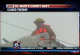
about half of the town here is essentially cut off. they have traffic that has been cut off from the route 90 bridge all the way south. they have also cut off electricity as a precaution, because we are seeing flooding in the southern end of the town here from 11th street south along the oceanside. the electricity has been cut off, as well as the second street to the inlet. that's a precaution, because you don't want to see those floodwaters causing any short or fire. at this point at this point, they're telling people the best thing to do is shelter in place. >> all right, sherry. we're going to take you to a live press conference where martin malley is giving a briefing now. we believe just seconds ago he mentioned that 75,000 people in the dark now in the state of maryland. that's expected to go up.
5:09 pm

let's listen in. >> we'll be continuing to monitor that through the night. so in conclusion, 75,000 outages so far. the storm is likely to make sooner than we thought because she is picking up speed along with picking up intensity, and we expect landfall in new jersey, steve correct me if imi'm wrong somewhere between 8 and 10:00 p.m.. >> okay. more like 8 p.m. and then the storm will make its way across maryland. so this is still a very violent and dangerous storm. we all need to act responsibly in order to minimize the potential for loss of life. this storm has already taken a lot of lives in the caribbean, and now it's moving back on to land here in the united states in our most densely plated areas. please stay indoors. we're not trying to scare anyone; but we are being honest. this is a dangerous storm, and you need the stay indoors. one incident to update you on
5:10 pm

in richfield. some of you go to the miller toss clambake in the summer on your way, way to the right, there's a housing community there called summer's cove. with the tidal surge that came up within the last couple of hours, it raiseed the water level such that it's about 3 feet of water spread all over the ground waters of summers cove. so serious as etc. from the volunteer fire department to johnson is here with us to the dnr, and their water as etc. are removing people from there. i don't know if you've been in chrisfield when it rains. that lower end takes to tend on a lot of water not unlike the downtown of ocean city in big
5:11 pm
rains. that's about the holiday yen at the boardwalk. 17th street. you can see the ocean pouring over the breakwall on to the boardwalk at 17th street. looks like a reporter getting a little too close for comfort. just a snapshot what's going on
5:12 pm

with the property loss that's currently occurring in ocean city in all sectors. we've seen photos like that and worse. and we know that sound of the landmark institutions, and businesses are taking on a amount of water. we're getting reports throughout the night. as you heard a short time ago, sandy expected to make landfall, officials warning residents not to take a gamble by riding out the storm, we'll have an update on the situation there when we come back.


5:15 pm

we want to welcome you back. our coverage continues. the chesapeake bay area keeping a close eye on the storm surge. >> parts of annapolis have already seen flooding. not as bad as it could be. john harion taking a look at things. >> john? >> reporter: high tide is not scheduled until 6:01, just under an hour from now. as you can see the water is not a particular problem. it's a foot and a half to 2 feet below. just an hour or so ago, there were people still strolling around. the wind has stiffnd, coming in at 25 to 35 miles per hour with some gusts higher, and now there's virtually no one out, at least in this part of
5:16 pm

annapolis. there are occasional cars cruising by a. couple of bars are open. but all stores and services are closed. about 80% of the gas stations about two hours ago when we cruiseed the town looking for diesel fuel from our truck, 80% of the gas stations were closed. there's some flooding in low- lying parts of anne arundel county, and there are road closures. here's a list, river road, south of harrell harbor closed because of standing water. defense highway, which is route 450 at stevens church road. that's the crossen area. the road is closed. one more for you. near the border of prince george's county, closed because of standing water. so though we do not have flooding in downtown annapolis, there's because of the heavy rains water on the roads. do not try to go through it if
5:17 pm

possible. if you need a shelter, it's annapolis high school. and we are told it is a pet- friendly shelter thanks to the help of some volunteers. that's the latest from downtown annapolis. >> hey, john, i saw a car there driving down city dock, and hopefully you can hear me. and i'm just wondering on a rainy night, and we're right now facing a category one, almost two hurricane coming to shore north of us. are you getting a sense it's because of the winds and the way the winds are blowing that's keeping the water. >> reporter: i don't know. these people are coming down to look. they were getting out of their cars and looking around. now the rain is so cold and so stinging, almost everyone is staying in their cars. as you can see at the end of the dock, nobody is out of course crazy tv reporters telling you about the storm. >> all right. john hanrahan, reporting tonight in annapolis. hurricane sandy expected to
5:18 pm

make landfall, of course, in new jersey within about the next hour or so. >> craig boswell joins us from a town that's right near atlanta city, new jersey where the storm is expected to come ashore. >> reporter: we have moved to higher ground as roads are turning into rivers as the worst of sandy is yet to come. >> reporter: high surf along with heavy winds and rains are pounding the east coast as sandy closes in. people have turned to caw ins to get around, hunkering down and preparing to ride the storm. >> generators, canned foods, water, anything we can. got the boats ready. >> reporter: all the while knowing the weather is just getting worse. going to be scary. once those winds get up there and gets dark and you can't see what's coming that will be scary. >> reporter: sandy is making landfall in south jersey as it joins up with two weather systems to create a massive super storm. >> president obama and local officials are warning the 50 million residents to take the weather system seriously or
5:19 pm

risk taking their own lives into their own hands. >> don't question the instructions that are being begin because this is a serious storm and it could potentially have fatal consequences of people don't act quickly. >> the days ahead are going to be very difficult. there will be people who die and are killed in this storm. >> reporter: authorities warn new york city may see the worst of the storm surge with sea water threatening to flood lower manhattan. >> not underestimate this storm. these forecasts for the surge are really extraordinary, and they're talking about surges that we have not seen before. >> president obama has declared emergencies in six atlanta states. craig beside well, fox news. let's take you downstairs to the weather department. what struck me at the top of this hour is they mentioned, sue and gary did, how the storm is speeding up and impacting
5:20 pm
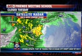
the area faster. i wonder if that's good sign in many respects. >> sue what's the word? >> reporter: i think it does a couple of things. first of all, hopefully we get the worst of the surge before the high tide. i know in new york city the tide is at 8:13. we think this will be on land before. we're hoping. it's hard to time all of that. out in ocean city, the high tide is 8:05. hopefully the surge is over before the high tide begins. so maybe that forward motion is a good sign. john, i wanted to answer your question you posted about why we're not seeing the tidal flooding. it's because the wind is out of the northwest. so it's not piling up just yet. eventually that might shift a little bit as the storm system gets more to our northwest and we get a south wind. right now it's pushing away. as we look at radar, as we watch big heavy bands of rain
5:21 pm
coming in, we're getting winds inside of them. let me put radar in motion. these are all spiraling in from the west; and as they're coming in, we picked up a gust to 68 miles per hour al wallops island. andrews air force base had a gust up to 54. i mentioned earlier, the 70 miles an hour gust as well as. the satellite and radar, as we go over to our mac system, the hurricane will be making landfall within the next hour, hour and a half. as you can see the system you can see it spinning there. the heavy rain pushing ashore, and within the next hour or so, you're going to hear that we had a landfall in the south jersey area. winds gusting to 02 in d.c., 43 at annapolis. we slide over to the coast, ocean city getting a gust to 00. it will probably come ashore
5:22 pm

somewhere between wildwood and atlanta city. and we work our way up to new york city and find islip at 69, jfk at 61. so a big storm surge expected as you heard the reporter saying maybe 6 to 11 feet in the new york harbor, 4 to 8 feet of storm surge. hopefully we get it in tonight. we're keeping an eye on it for you. >> sue is this window shrinking? >> i don't think so, brian. in fact, i want to remind everybody it will be a windy today, the worst of the wind between now and 3 in the morning. the core of it when we get the potential for gusts and higher in a few spots. i still didn't tell you we have a blizzard warning in the mountains above 2,000 feet. so snow is part of sandy's
5:23 pm

package, too. >> all right. thanks. >> just a quick update for all if you who are x factor fans. want to let you know you can watch the show tonight at 8:00. we'll continue our storm coverage. but you can see it on wdca tonight. president obama said he's confident state and federal governments have done all they can to prepare for the storm. coming up the warning he's sending to the public and the impact sandy could have with election day a week away. teacher: t his isest virginia, pennsylvania, delaware. and this is ryland. every marylanders spend five hundred and fifty million gaming at casinos in these other states. question seven will build a new casino and bring table games to baltimore... generating hundreds of millions for schools. and that money has to go to education. it's the law. so vote for question seven. so we can stop spending all that money here, and keep maryland money
5:24 pm

in classrooms like mine. prand you're seeing that rightno quit in amnow.a... over five million new jobs. exports up forty one percent. home values... rising. our auto industry... back. and our heroes are coming home. we're not there yet, but we've made real progress and the... last thing we should do is turn back now. here's my plan for the next four years: making education and training a national priority; building on our manufacturing boom; boosting american-made energy; reducing the deficits responsibly by cutting where... we can, and asking the wealthy to pay a little more. and ending the war in afghanistan, so we can... do some nation-building here at home. that's the right path.
5:25 pm

so read my plan, compare it to governor romney's... and decide which is better for you. it's an honor to be your president... and i'm asking for your vote... so together, we can keep moving america forward. i'm barack obama and i approve this message. ocean city, maryland. you know what we need to find
5:26 pm
out is where exactly sherry lee is in ocean city. it doesn't look like -- she's at the boardwalk, obviously at a hotel shelter. doesn't look like the waves are pushing up as far up in her part of the boardwalk as we have seen pictures in the past. we know the waters are are not receding. the waves not as choppy as they have been. an alert came across from the town of ocean city on facebook. the route 90 bridge is being closed to nonemergency vehicles dow to the increasing windsnd rain. it will be closed at 5:00 p.m., which has just passed asking all citizens to go ahead and stay indoors at this hour. the last bit of news is that they're expecting about 10 inches or so of rain, 4 to 50 miles per hour gusts. they're saying it appears there's a lull in the storm, and warning folks not to take the lull as the storm being over and that perhaps it's part
5:27 pm

of the eye and the winds will pick up again. stay on your guard. >> let me ask you a little bit about the lull brian was asking about. >> what can we expect as we continue the roll on here? >> i wish we could say we missed the worst; but we're getting into it. things will go downhill between now and say 3, 4 in the morning with increasing winds and gusts. seeing it already. i do believe the power outages will continue to build. and to answer brian's question, out at the beaches you may be beginning to see the leading edge of the center of circulation coming ashore. i would expect that to happen within 0 minutes or so if it hasn't already begun. so you might get a brief lull on the other side of it. but the worst side of this particular hurricane has been the west side unusually. piled up a lot of water. i mentioned this storm had a snowy side. i thought we would show it to you this time.
5:28 pm

we have blizzard warnings, folks, already starting to show up as snow well west of harrisonburg. when you get to elevations above 2,000 feet, we could be talking about a foot of heavy wet? that's beginning tonight. you can see it now is. >> not quite into actual pepper, but seeing that down toward madison and green. so charlottesville some of those high elevations within about the morrow county will get some snow. if you take it to 3,000 feet we could be talking about a foot and a half to 2 feet of heavy wet snow. we're very concerned that a lot of trees will come down and power outages in them. would not be shocked if this ends in wet snow later tonight as well, and also wanted to mention what is going to be happening in the next little
5:29 pm

while is a big storm surge, it is still a hurricane with 90 miles per hour winds, a 4 to 8- foot storm surge widespread expected through the ocean city area into delaware bay, and up the coast to theth katie/rhode island border with an exception. and the exception is the new york city area and the harbor. because of the features being a little bit of a bowl, as this water is funnel in, they're looking at potentially the biggest surge they've ever seen of 6 to 11 feet. now we're hoping that the surge will be over before perhaps the high tide at 8:13 sets in. but the biggest surge they've ever had is 10 and a half feet. that was with hurricane donna in 1960. with irene they had a 9-foot surge. it is expected to be between 10 and 12 feet at the battery, and that would be major flooding for the new york city harbor as well as the long island sound,
5:30 pm
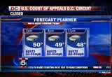
the water. >> we heard a lot if our reporters mention how cold it is. this is a cold. you would never believe this is a tropical system, and that's because it's in the process of becoming a winter system. here is your planner, at 7:00 at 50 degrees with the gust of 50 to 05. we're already picking up a few spots getting 70 miles per hour gusts. we keep it going at 9:00. and big winds of 60 to 65, gusting at 10 with a temperature of 48 degrees. much more to come. we'll squeeze the forecast in and give you hope in case you're tired of hurricane sandy and her many facets. >> back to you. >> i'm looking at the three-day forecast. i don't need 7 days. >> just give us wednesday or thursday, too. >> yeah. >> it's not just your life that's being put on hold. the presidential campaign is on hold as a result of sandy. >> president obama monitoring
5:31 pm

the track of hurricane sandy and the response efforts. >> earlier this afternoon, the president spoke from the white house urging residents in sandy's path to heed warnings from local officials. tom is live with the very latest. tom is this. >> good evening. the president actually handed at andrews joint base earlier in maryland and made his way to the white house. once there the president made a brief statement at the briefing room today, basically running down the briefings he has had with many of the fema and federal officials in charge of this response. the president said he has directed all arms of the federal government to make sure that the food, water and other rescue resources are in place in the areas needed up and down the east coast. more specifically, though, the president's message was to those people who would find themselves in any evacuation zone. in some of his most direct language, the president basically said if you do not
5:32 pm

heed these warnings or follow the instructions of local officials well in the president's words this could be a fatal situation. >> the most important message that i have for the public right now is, please listen to what your state and local officials are saying. when they tell you to evacuate you need to evacuate, do not delay, don't question the instructions being dna, because this is a serious storm, and it could potentially have fatal consequences if people haven't acted quickly. >> reporter: now as the president can say that it remains to be seen whether or not people will actually do that. as brian pointed out quite correctly earlier, there are some people who live at the shore all yearlong and have experience on how to ride out these storms. at this point as we get another
5:33 pm

gust, at this point, the federal government said with. they feel they are prepared and prepositioned where they need to be. we will have to see as this hurricane unfolds exactly if they have chosen right. as to where they are prepositioning all this equipment. we are expecting another briefing from fema within the next couple of hours to get a more detailed assessment as to where they think the biggest impact is. brian and shawn, back to you. >> let me ask you quickly. i believe you're at northeast 8th street. i know we're talking about politics. let me ask you about the area where you are. how have things changed? >> as you mentioned, this is harrison and wisconsin. it's a neighborhood basically devoid of any large trees; but one of the things that we do see is that there are a lot of power lines and clearly that is
5:34 pm

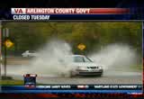
a big concern. we are at the mercy of which wind blows and which tree false on which power lines. about 20 minutes ago we heard a loud boom in this area of friendship heights. we dot new orleans if that was a tree coming down on a car or a transformer. i don't think it was, because clearly you can see the power is still on in this area. but it's a good reminder though this might not be right now what a lot of people may think would be a treacherous situation; but clearly when you start hearing the booms and loud bangs reminds you how quickly things can turn if you're not on your toes. >> 8th street the nickname we give for harrison street right outside the station. thanks for the update tonight. there are also concerns about flooding in parts ofs agoryia, virginia. >> as always, parker there
5:35 pm

tonight. how are things looking? >> reporter: hey, brian. not a particularly good night for a stroll in oldtown; that is for sure. it is cold, it is rainy, and we are seeing the winds pick up just a little bit. a little more of a push across the water. the boats are gentlying are youing back and forth behind me. it is good morningmy, hazy, hard to see. there are people out here walking around, kind of checking things out. i talked a couple of minutes ago to a lady visiting town from new mexico. folks walking right by here. she said she came from new mexico and wanted to take a peek, because they do not get health insurance in new mexico. she said it hardly ever rains where she lives. so on lookers checking things out. we have not seen a dramatic difference in the weather. a little more wind and rain; but it has not been the kind of real hard gusts we're seeing
5:36 pm

out at the beach. only people who know old towns agory know this is an area that is certainly prone to flooding. we have not seen -- there's a little more wind and rain coming through. there's somebody out there in a sailboat. not the best idea. authorities want people to go home. this is an area prone to flooding. you can expect there will be trouble. businesses have closed. the starbucks closed. a half of places still open. the places open are packed with people inside, people walking into the few restaurants that are open here. so certainly as the day goes on, the night goes on, this will get to be a much more dangerous situation, and the mayor joined us earlier and he said all he wants is for people to go on home. live, i'm beth parker. back to you, brian. >> storms are always a tale of two stories, those who stay home and ride out out on the couch in their computers, and those who want to go out and live it up a little bit; and, you know, go get a dinner and a
5:37 pm

glass of wine. each to has their own. >> no matter what they're doing, you can keep it here on fox 5. we'll keep you updated with the latest. pep key saying about 2,000 workers are on stand-by to get the power back on. how they are preparing for sandy's rival and the outages in our area. keep it here on fox 5. anncr: it's said that character is what we do...
5:38 pm

when we think no one is looking. mitt romney: believe that they are victims. anncr: mitt romney thought no one was looking when... he attacked forty-seven percent of americans. his companies shipped jobs overseas. his plan cuts millionaires' taxes, but raises yours. he'll voucherize medicare... and make catastrophic cuts to education. so remember what romney said... and what his plan would do. president obama: i'm barack obama and... i approve this message. we were told to build a 30-foot stage. gathered the guys and we built that 30-foot stage, not knowing what it was for.
5:39 pm

just days later, all three shifts were told to assemble in the warehouse. a group of people walked out on that stage and told us that the plant is now closed and all of you are fired... i looked both ways, i looked at the crowd, and...we all just lost our jobs. we don't have an income. mitt romney made over 100 million dollars by shutting down our plant and devastated our lives. turns out that when we built that stage, it was like building my own coffin, and it just made me sick. [ male announcer ] priorities usa action is responsible for the content of this advertising.
5:40 pm

2800 outages so far. pep key said it's ready to deal with the monster storm regardless. >> they called it an unprecedented storm. they say it may be a while before they get that power rerestored. >> it may exand the more than a week after the storm has passed. it's important to note the conditions may not allow us to go out initially, and then we'll have to start that assessment period. pep key said more than 2,000 contractors will be on the job to deal with the after the of the storm.
5:41 pm

he believes workers will begin to assess the damage tomorrow. we'll keep you updated with the latest with pep key and the other power companies tonight and through tomorrow morning. stay with us. ith us. anncr: their ads, hopelessly untrue. a west virginia casino launching the biggest ad barrage ever. don't be misled. the washington post says question seven is just... common sense. it'll create 4,000 permanent jobs. and stop maryland from losing millions to other states... every year. that's why business, labor, and teachers all support... question seven. and so does the washington post. vote for question seven. it's just common sense.
5:42 pm

what mitt romney's tv ads say about women? or what mitt romney himself says? mitt romney: do i believe the supreme court... should overturn roe v. wade? yes. and it would be my preference that they, that they... reverse roe v. wade. hopefully reverse roe v. wade. overturn roe v. wade. planned parenthood, we're going to get rid of that. i'll cut off funding to planned parenthood. anncr: no matter what mitt romney's ads say. we know what he'll do. president obama: i'm barack obama and... i approve this message.
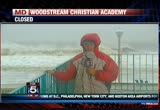
5:43 pm

a live look ats agoryia, virginia. where you can see it is not too terribly bad, people being urged to stay off the water, off the street. we'll keep an eye on this situation. beth parker is sycesing the situation. we'll have a live report from her. >> bob bar forward is live with more on crews, already out, and the way some people are gearing up for the storm out there. bob? >> brian, a lot is going on
5:44 pm
that we can't show you except for the rain, the wind. it is cold and nasty. few -- this was at 4:30 this afternoon. they told us they were up there to take the power off of one line that was going up a street so they could do tree trimming in this weather. this was more than an hour ago. some neighbors came out to us and said they had the paperwork. they said this was a work order that went out in august. here it was the evening of the storm. pepco out out there doing tree trimming the weather not prohibitive for them to do some work. so this was the worst of it, work being done. >> can show you another video along wisconsin avenue. we're at wisconsin and woodmonth. this was south of here with standing water that a lot of
5:45 pm
motorists didn't realize. that's been some of the problems, some flooding mainly in the roadways where it dips a bit where maybe the storm drains are clogged. so you have to be really careful, because there's standing water, and it can make for treacherous driving which was on the other side, heading north on wisconsin, a fender bender we came upon because of this flooding. why are these people out? some of them were doing last- minute shopping. we saw some of the folks at the hardware store in bethesda. bethesda. >> reporter: i'm not sure. we saw a man who toll us he had just bought a house, was closing on the new house today, and was getting protective shields so the wells didn't
5:46 pm

flood. we can show you some of the people were out with umbrellas flying the other way. we had seen people on bikes. we saw one guy, jason blitz jogging earlier. >> i've got to get out and run. the gym is closed so what else am i going to do? i thought i would see somebody else running, because it's not too bad. >> there have been a lot of people out earlier. not right now. it's getting worse. what do you make of the conditions? >> i actually feel warm. this is nice. i like running in the rain. i don't know if i'm crazy enough to do this at 8 or 10 p.m. you've got to try to exercise when you can. >> some people are out here. the market was going to be open normal hours. most of the businesses are closed. we've seen a lot of sandbags protecting doorways. so it's bad. it's been getting worse. some people are out and about and ignoring it to some degree.
5:47 pm

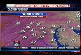
>> that's the story of every storm. bob barker, with the weather tonight. >> we have the very latest on hurricane sandy. >> we expect a landfall shon and brian. we've been keeping a close eye, because they'll send out a bulletin. the last update we had was at 5:00. it was 30 miles to the southwest of cape may, and 40 miles away from atlanta city. so probably be at delaware bay, a southern jersey. the motion is continuing sending a heavy band of rain. >> we can see that, too, if you switch on over here. want to start with a look at the radar. i was looking independently at some of the wind gusts and the only way we can apply them is in knots. so basically with a 44 naught wind around d.c. your ear talking about 50 to 52 miles per hour wind gusts.
5:48 pm

i want to put temperatures on real quickly, so you can see the temperatures with the wind. it is chilly out there. some spots have dropped down into the middle 40s; and as this hurricane is making its landfall within the next half hour to hour, we'll have the hurricane meeting one this tropical, with this cold front which is when it will turn into this post-tropical or extropical storm system and lose the tropical characteristics that have been keeping it a hurricane. so the wind out there has been blowing, and we're getting -- i have to believe that over the curse of the next few hours, we'll continue to see the higher gusts move ashore or move into the area, and what that means is th begin to see the wind gusts that now have gotten over 50 miles per hour in some cases. we'll get up to 60 miles per hour. to be honest with you, this storm has been forecast so well.
5:49 pm

the modeling has been doing such a good job that what happens since it's been such a good job, all we can assume is that the modeling is going to continue doing a wonderful job. and to some extent since this is an unpressed storm the models may be underestimating some of what it has to offer. so we do believe over the next few hours, these winds will continue to go up. we don't want it to happen. we hope it doesn't happen, but it very well may. >> and that's something we're hearing. people are saying this isn't as bad. we are in the moderate stages. some rains coming in. we've had reports in uric of close to 4 inches of rain. frederick county, new market over 3 inches, columbia has had 4 inches already. we have many hours of rain to go. gary you mentioned this is one of the areas where we may be underdoing rain. but some of you might get
5:50 pm
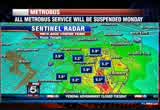
closer to a foot of rain out of this, already out toward berkeley county. there's been 3 inches of rain out there, and big winds. we've seen 70 miles per hour gusts here and there, including 70 miles per hour gusts from amedinab at fishing creek and a coldville report in g of a 70 miles per hour gust. check out the rain totals as seen by our doppler radar estimate and wow 6 and a half. that was down toward lower southern maryland into the bay where yesterday we had a persistent band that didn't want to move, but the bands are moving west. when one comes through your area you may pick up another inch of rain. >> that's exactly right. you can see -- i think there may be later this evening, a bit of a lull; but as the storm continues to track west northwest, it will bring more rain back around. so quickly looking again at the radar with this, and there's still this big patch of rain,
5:51 pm

heavy rain from the bay out to the shore, which is tracking westward into the area, and i think that's where we'll see the real high winds pick up. >> notice no rain in atlanta city city, so we have our center of circulation very close. not much going on on radar there. so the headlines, the worst effects continuing now through probably 3, 4:00 in the morning, then as we peak out with those gusts, we'll can't to have strong winds during the day tomorrow. probably on the order of 30 to 40 miles per hour gusts >> this is good with landfall. since the storm sped up, it increased earlier this afternoon. i think that was a little bit faster than what was anticipated by the hurricane center, so landfall on the other side of that. we're waiting now for the announcement from the hunt center that it has, indeed, made landfall probably a little bit south of atlanta city. >> we've got sustained winds of
5:52 pm

30 to 50 here at fox 5. we've got a wind at 6 miles per hour. is that a gust or sustained? >> we've been getting gusts occasionally. right now there's a lull. >> not going to be constant. >> not at all. sustained winds. we have sever it, too, because we've been seeing sustained winds up over 30. last winds gusting to 70, maybe higher, and expecting rain totals to top 10 inches. heavy mountain snow. we see the snow showing up on radar. that's going to be 6 to 12 inches at 2000 feet. a little wet snow mixed in in our to burr,s. one of our models have suggested that. we think the models have handled this well. >> so west, northwest movement at 10 miles per hour. this is as of 5:00. they're issuing these every hour. we haven't seen the pressure drop. we have not signed the wind
5:53 pm
speed. keep in mind, hurricane hunter aircraft are still out in the storm moving through the storm, looking for any change in pressure, looking for any change in wind. >> so 00 miles per hour winds now. at two in the morning as it sycosessing the mason kick sob line, it will be a hurricane with winds of 75 miles per hour. so the winds will continue for a number of hours, and they are going to cause damage, and approach the forecast is on track. >> and typically with the landfalling hurricane like this, you would see, as the hurricane moves ashore, you begin to see tropical storm sandy, and that will last for -- it goes right to what we call post-tropical or extra tropical as it's coming into this cold air, the nature of this storm is transitioning into well nor'easter. >> yeah. >> what an october. >> we'll let you know when we officially hear it has reached land. that will probably be within the next 30 to 45 minutes. >> back to you, brian and shawn. >> thanks so much. [ minto ] you know, those ads saying mitt romney
5:54 pm

would ban all abortions and contraception seemed a bit extreme. so i looked into it. turns out, romney doesn't oppose contraception at all. in fact, he thinks abortion should be an option in cases of rape, incest, or to save a mother's life. this issue's important to me, but i'm more concerned about the debt our children will be left with. i voted for president obama last time, but we just can't afford four more years. [ romney ] i'm mitt romney and i approve this message.
5:55 pm

[ romney ] i'm mitt romney my name is julian bond. i know a little something about fighting for what's right and just. maryland's gay and lesbian families share the same values and they should share in the right to marry. i believe people of faith understand this isn't about any one religious belief. it's about protecting the civil right to make a lifelong commitment to the person you love. join me in supporting question 6.

5:57 pm

you can some in and get a close look at your neighborhood or zoom out and get a wide view, a scope of how grand this hurricane is. so that's one aspect of it. of course the pictures that we can't be everywhere, and we want you to help us out and get your mobile devices out, snap photos and click on the submit feature on the fox 5 weather app. once you do that you'll have applicants is to your own gallery of photos on your smartphones. you can up load it. this is a look at one of the
5:58 pm

photos right now that has been sent in. this is damage in ocean city on the boardwalk, some of the bench that report delay were bolted to the ground were strewn. you can -- how about that photo of walmart in centreville? if you look closely a lot of shelves will be empty with food and water. if you look this is ammunition, folks getting ready for any scenario. feel free to download that weather app at d.c. weather. you can submit photos by e-mail as well. the e-mail address is myweather photo at gmail.com. and keep your smart phones charged, your i-phones, tablets and all that. keep them charged before you lose power. send it to you guys. >> scott, thanks. >> we'll be right back as our coverage continues. presid ent oba: there's just no quit in america... and you're seeing that right now.
5:59 pm

over five million new jobs. exports up forty one percent. home values... rising. our auto industry... back. and our heroes are coming home. we're not there yet, but we've made real progress and the... last thing we should do is turn back now. here's my plan for the next four years: making education and training a national priority; building on our manufacturing boom; boosting american-made energy; reducing the deficits responsibly by cutting where... we can, and asking the wealthy to pay a little more. and ending the war in afghanistan, so we can... do some nation-building here at home. that's the right path. so read my plan, compare it to governor romney's... and decide which is better for you. it's an honor to be your president... and i'm asking for your vote... so together, we can keep moving america forward. i'm barack obama and i approve this message.
193 Views
IN COLLECTIONS
WTTG (FOX) Television Archive
  Television Archive News Search Service
Uploaded by TV Archive on
